Friday, July 18, 2008

Agility-Mama's post July 18


Last night Bear & I went to our third doggie agility class & wow is that fun!!!! This "Agility Confidence Course" is an intro to the sport.

With pockets full of irresistible treats we gathered with a small & varied pack of dogs; 2 border collies, lab, golden, schipperke, aussie cattle dog, & mixed breeds. First the doggies had to "warm up" their muscles just like any athlete , so we trotted around & Bear followed treats in circle after circle.

Then we got to play with the equipment! I am amazed at the good nature & trust of this good pup. With me running along side him, he tackled:

--> a long straight tunnel
--> a long curved tunnel (more tricky 'cuz there's not a direct view of the end)
--> a 12-inch wide "walk" that has a ramp going up, straight section, then ramp down
--> a steep a-frame
--> small jumps
--> weave poles, set not in a direct line but slightly apart & with guiding wires, so the pup can begin to get the idea)
--> a teeter-totter with the instructor's help (she held the end of it & when he reached the 'balance point', she eased it gently down while I fed him incredible nummies, it was all very rewarding!!)

After working on these individual obstacles, we got to try a few in a sequence and that was a hoot, I fell flat on my arse once and I wasn't the only one on the ground, ok next class I'm wearing my sneakers as it's not easy to keep ahead of a pup!

During & after class Bear was all grins & it felt good to make him "think". It was a blast!!

Sunday, July 13, 2008

Fun, Fun, Fun

Yesterday was spent locating and logging geo-caches in the Waterloo area just east of Lebanon as well as lots of fun in the sun on the Santiam river with a friend of ours and her two small rafts. We let the dogs play in the river first while the kids looked for treasure. Then we moved to a little better location where we could "put in the river". Needless to say we used lots of sunscreen.

We found seven of eight geo-caches we went in search of. One was listed as being easy but it eluded us. After reading some of the logs others posted, I think I know where to look next. If you want to know more about geo-caching, go to www.geocaching.com.


Sorry, no pics.

Sunday, July 6, 2008

Free walking sticks

If you want a bug pet my walking sticks are great you get 2 free. I have like 56 57 58 59 60 61 62 63 64 walking sticks! call xxx-xxxx for 2 free walking sticks

Alex intro

Hi... I am Alex Gale. This is my familys blog. I have no idea what to write. I will just use it for...
watever I want! Yeah. Whatever I WANT! So I'll use it for uh... Something!yeah something!

Friday, July 4, 2008

Day 6 Saturday June 28th


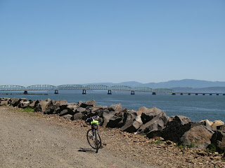
This is the last day of the ride. We started fairly strong and finished even stronger. Another day with a tail wind! This first picture is of the south end of Willapa Bay. The next picture is of Astoria with Saddle Mountain shrouded in the background with smoke. The third picture is of the Colombia River where I stopped to fix my first flat of the season. The last series of pictures are in Astoria enjoying a cool glass of sparkling apple cider and a celebratory bike lift. All total, 6 days and 323 miles. Up next, I think we are riding part of the Gorge.

Day 5 Friday June 27th


My legs hurt so much this morning that I decided that I couldn't make the entire ride today. My buddies left on time and I stayed to play on the beach with my family. We collected more Sand Dollars than we could carry and found a nice place out of the wind to watch the kids play. About noon I realized that it was a north (tail) wind and I thought I would start and see how far I could go while Wendi wrapped up the rest of camp. She caught me 25 miles later and we stopped for lunch. At this point I was feeling great and decided to continue the rest of the way. I completed the ride about 45 minutes after my buddies did, over 50 miles.

The top two pictures are of Willapa Bay. The third picture is of a make shift shop, where we sometimes have to work. The last picture is my buddy enjoying a well earned rest.

Day 4 Thursday June 26th


Today we rode from Lake Quinault to Twin Harbors State Park. The original plan was to ride the ferry across Grays Harbor saving many miles but alas, we found out only after the ride started (by Wendi calling us and leaving a message) that the guy who runs the ferry was not doing it this year. :( So we changed course and headed to Aberdeen. This day was tough for me and I decided not to ride the last 20 miles from Aberdeen to the park and arranged to get picked up. My buddies thought this was a good idea as well and we were all picked up and shuttled into camp that night. Still, we rode 50 miles, a very respectable day.

Day 3 Wednesday June 25th Part 2


While the big boys rode down the coast, Wendi and the boys went with some friends further south and stayed a couple of night at the beach in some yurts. As you can see from these pics, they had a fantastic time both climbing around in the trees and at the beach getting very wet and sandy. Lastly, a nice warm campfire warmed and dried everyone. Of course the smores were a nice addition.

Wednesday, July 2, 2008

Day 3 Wednesday June 25th Part 1


Today we went from Bogachiel State Park to Quinault Lake, a total of 65.4 miles. Lots of this ride took place next to the beach though the last third went back inland. This first picture is of a bald eagle on a rock. We saw plenty of these wonderful creatures throughout our week. The second picture is of my buddies looking for a photo op.

Day 2 Tuesday June 24th


Tuesday we rode from Port Angeles to Bogachiel State Park, a total of 70.6 miles; Our longest day with the tallest mountain. This first picture was taken as the sun rose and hit our tent about 5:50am or so. Our tent is so huge it has three separate wings on the inside. We could easily sleep three families in there. Of course it takes a village to put it up but we don't mind. It allows our dogs to have a wing all to themselves. The second picture is of our two dogs, Raini and Bear. They are both well behaved and a joy to have in camp. This third picture is of Lake Crescent. We rode around the south side of the lake. The road here was decent if not very wide. The last picture posted is of one of my riding buddies as he gets off the bike to push the caution button to start the flasher lights. The sign warns bicycle riders that large RVs and log trucks use this eleven mile stretch of rode characterized by blind corners and very narrow roads. After the lake there was a climb up to 1200 feet and what was supposed to be a 30 mile descent though the head wind took the sails out of that excitement pretty quick. Once we made it to Forks, it was pretty short work to make it to the state park.

Day 1 Monday June 23rd


Day 1 went from Port Townsend to Port Angeles for a total of about 46 miles. We got a late start as we spent considerable time at camp getting ready and once we finally arrived at Port Townsend we spent the better part of an hour looking for a Geo Cache. We did find it but we ended up with pretty scratched legs. The ride itself was great. We stayed on Highway 20 until it met up with Highway 101 going up and down several rather large "hills". The highway 101 part went fine as well though there was lots of traffic. We ended up in camp around 4:30 and had a fantastic dinner.

Tuesday, July 1, 2008

Bike Ride Start


This is me and a couple of buddies starting in Port Townsend Washington on our way, via bike, to Astoria Oregon in six days. Our families did the ride support so we didn't have to carry gear with us.